AUGUST 2010
UNPREPARED FOR THE WORST
The level of earthquake readiness does not always match the risks
Illustration by Rich Morgan
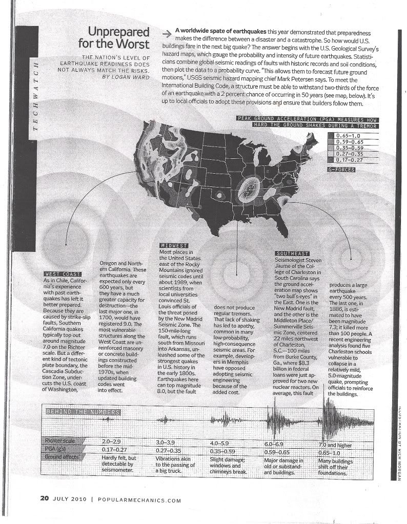
A worldwide spate of earthquakes this year demonstrated that preparedness makes the difference between a disaster and a catastrophe. Finding out how buildings would fare in the next big quake begins with the US Geological Survey’s hazard maps, which gauge the probability and intensity of future earthquakes. Statisticians combine global seismic readings of faults with historic records and soil conditions, then plot the data to a probability curve. “This allows them to forecast future ground motions,” USGS seismic hazard mapping chief Mark Petersen says. To meet the International Building Code, a structure must be able to withstand two-thirds of the force of an earthquake with a two per cent chance of occurring in 50 years (see map, below). It’s up to local officials to adopt these provisions and ensure that builders follow them.Weat coastAs in Chile, California’s experience with past earthquakes has left it better prepared. Because they are caused by strike-slip faults, Southern California quakes typically top out around magnitude 7,0 on the Richter scale. But a different kind of tectonic plate boundary, the Cascadia Subduction Zone, undercuts the US coast of Washington, Oregon and Northern California. These earthquakes are expected only every 600 years, but they have a much greater capacity for destruction – the last major one, in 1700, would have registered 9,0. The most vulnerable structures along the West Coast are unreinforced masonry or concrete buildings constructed before the mid- 1970s, when updated building codes went into effect.Mid-weatMost places in the United States east of the Rocky Mountains ignored seismic codes until about 1989, when scientists from local universities convinced St Louis officials of the threat posed by the New Madrid Seismic Zone. The 240 km fault, which runs south from Missouri into Arkansas, unleashed some of the strongest quakes in US history in the early 1800s. Earthquakes here can top magnitude 8,0, but the fault does not produce regular tremors. That lack of shaking has led to apathy, common in many low-probability, high-consequence seismic areas. For example, developers in Memphis have opposed adopting seismic engineering because of the added cost.South-eastSeismologist Steven Jaume of the College of Charleston in South Carolina says the ground acceleration map shows “two bull’s-eyes” in the East. One is the New Madrid fault, and the other is the Middleton Place/ Summerville Seismic Zone, centred 35 kilometres northwest of Charleston – 160 kilometres from Burke County, Georgia, where R62 billion in government loans has been approved for two new nuclear reactors. On average, this fault produces a large earthquake every 500 years. The last one, in 1886, is estimated to have been magnitude 7,3; it killed more than 100 people. A recent engineering analysis found five Charleston schools vulnerable to collapse in a relatively mild, 5,0-magnitude quake, prompting officials to reinforce the buildings.Behind the numbersRichter scale2,0–2,93,0–3,94,0–5,96,0–6,97,0 and higher
PGA (g’s)0,17–0,270,27–0,350,35–0,590,59–0,650,65–1,0
Ground effectsHardly felt, but detectable by seismometer.Vibrations akin to the passing of a big truck.Slight damage; windows and chimneys break.Major damage in old or substandard buildings.Many buildings shift off their foundations.


No comments:
Post a Comment
Note: Only a member of this blog may post a comment.